Modelled
Data
Source: ERA5/ECMWF, Copernicus Climate Change Service (C3S)
Method
The methodology used to generate the modelled climatology for mainland Portugal is based on the implementation of a dynamic downscaling process, using the numerical weather prediction model WRF (Weather Research and Forecasting Model) version 4.2 (Skamarock et al., 2008).
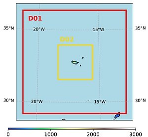
The WRF model is a non-hydrostatic model, suitable for simulating a wide range of spatial scales, from thousands of kilometres down to a few metres. Its core offers a wide selection of physical parameterisation options, making it highly suitable for a variety of applications, including climatological studies.
Dynamic downscaling is essentially a numerical process that requires intensive computational resources, implying a substantial processing time. To minimise model errors, several short-duration tests were performed to define the set of physical parameterisations used (following Miranda et al., 2020). These tests also revealed that, in order to reduce computational time for the Azores Archipelago, the most efficient approach is to divide the islands into three high-resolution subdomains, each covering a different group of islands.
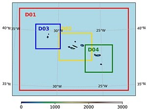
The simulations were forced every 3 hours using ERA5 reanalysis data (Hersbach et al., 2020). The configuration included two nested domains, with the outer domain (D2) having a horizontal resolution of 9 km, and the inner domain (D3/D4/D5) a resolution of 3 km.
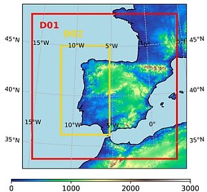
Historical simulations cover a period of 43 years (1979–2022), producing two climatological normal periods: 1980–2010 and 1991–2020.
This set of climatic indicators:
- Corresponds to the simulated climate for three regions: mainland Portugal, the Azores Archipelago, and Madeira; and is provided on monthly, seasonal, annual, and 30-year climatological normal periods.
- Will be available for the following spatial aggregations: municipalities (concelhos), districts, NUTS3 regions, and river basin regions. The spatial statistics include minimum, mean, and maximum values for each territorial unit.
- Will be updated according to the integration frequency, with monthly integrations updated at the start of the following month (by the 8th day), depending on the release date of the ERA5 reanalysis dataset.
Indicators
The list of climate indicators provided on this platform is based on those used in the processes related to the monthly monitoring carried out by IPMA.
In the first phase, the following indicators were processed:
- Mean, minimum and maximum air temperature
- Number of days with minimum air temperature < 0 °C (cold days)
- Number of days with minimum air temperature > 20 °C (tropical nights)
- Number of days with maximum air temperature > 25 °C (summer days)
- Number of days with maximum air temperature > 35 °C (very hot days)
- Number of days with maximum air temperature > 40 °C (extremely hot days)
- Total precipitation
- Days with precipitation > 1 mm (number of wet days)
- Days with precipitation > 10 mm (number of heavy precipitation days)
- Days with precipitation > 20 mm (number of very heavy precipitation days)
- Days with precipitation > 30 mm (number of extremely heavy precipitation days)
- SPEI (3, 6, 9, 12 months)
- SPI (3, 6, 9, 12 months)
- Aridity index
- Reference evapotranspiration (ET₀)
Error
Understanding the error associated with climate modelling is essential in order to evaluate the performance of the simulations from the perspective of representing the climate of Portugal’s regions. For this purpose, an assessment of precipitation and maximum and minimum air temperature was carried out for the WRF downscaling simulations, comparing the model output with datasets resulting from IPMA’s surface observation programmes. To simplify the comparison, all statistics are based on averages derived from the individual results of the different available stations.
The WRF model was validated using observed data from IPMA’s meteorological station network for the same time series, with modelled values for air temperature found to be slightly underestimated.
The results obtained using dynamic downscaling (WRF/ERA5) were analysed by comparison with data from 109 meteorological stations (IPMA and APA networks) for the period 1981–2010. In summary, precipitation is generally underestimated by the model at the locations where the stations are installed.
The highest residual intensity and spread occurred in October, November, December and January. July is the month with the smallest error, also being the driest month.
The first figure shows observed values minus modelled values for each station location.

The second figure shows the same analysis—observed minus modelled values—but expressed as percentage differences.
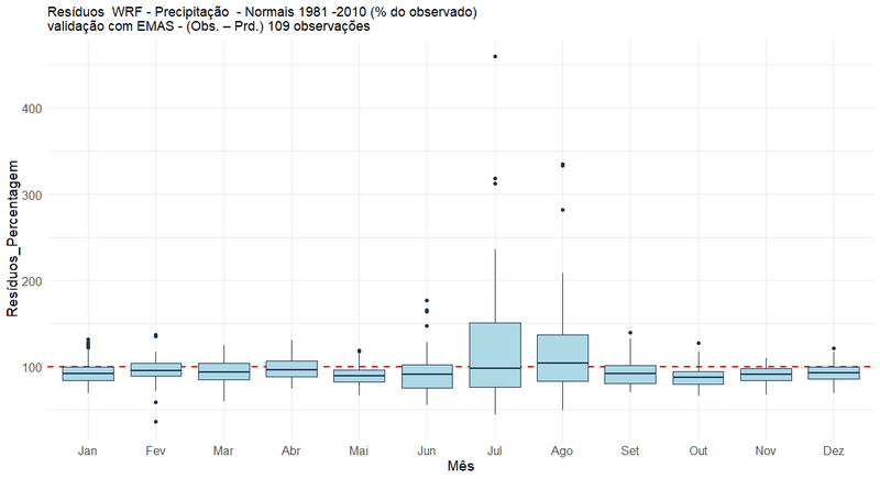
The following table presents the RMSE, MAE and MBE values.

Air temperature
The behaviour of the WRF model presents different results for minimum, mean and maximum air temperature.

For minimum air temperature, residuals remain within the range -3 °C to +3 °C. This interval decreases to -2 °C to +2 °C for mean and maximum air temperature.
The best model performance is seen for maximum air temperature, while performance is less accurate for minimum air temperature.
The following table presents the RMSE, MAE and MBE values.

Observed data
Data
Source: Meteorological stations from the IPMA network
Method
The climatological data provided on this platform were obtained from meteorological stations within the national climate reference network. These stations must at least record air temperature and precipitation, although other climatological parameters should also be included in the observation programme, such as wind direction and speed, air humidity, atmospheric pressure, solar radiation and soil temperature.
The selection of meteorological stations represented on this platform was based on the following criteria:
- The observation programme includes the listed parameters;
- Currently operational;
- Part of the current IPMA weather-station network;
- Long historical series available (covering at least two climatological normals, wherever possible);
- Spatial distribution representative of the territory and its regions.
The calculation of monthly data was carried out in accordance with World Meteorological Organization (WMO) standards. Missing values for air temperature and precipitation were supplemented with model data, namely ERA5 (the ECMWF reanalysis dataset) and WRF (Weather Research and Forecasting Model).
The temperature and precipitation series from the selected stations were tested for homogeneity using the RClimDex software package.
In some stations, breakpoints (significant shifts in data values) were identified and subsequently validated or rejected after metadata verification (see figure in this section with an example for Porto/P. Rubras).
For climatological normals, processing was carried out using observational datasets, duly validated through quality control procedures. To calculate the normals, monthly values for each parameter were first determined, then annual values, followed by 30-year averages in line with WMO standards.
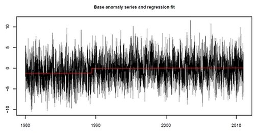
Figure 4. In the presented figure, a breakpoint is identified in the maximum temperature series for Porto/P. Rubras meteorological station.
Description of manual weather stations
The descriptive information presented on manual weather stations was based on information available in the book published by the Serviço Meteorológico Nacional (currently IPMA):
Ferreira, H. A. (1970). O clima de Portugal: Normais climatológicas de Portugal Continental, Açores e Madeira correspondentes a 1931–1960 (Fascículo XIII, 2ª ed.). Serviço Meteorológico Nacional.