dataClima
Dataclima is an interactive digital platform that provides access to modeled and observed climate indicators for the Portugal mainland and island regions. The modeled climate indicators are made available since 1981, for the various territorial units and aims to support the most relevant activity sectors.
January 2025 - monthly summary

The preliminary summary of the climatological bulletin for January 2026 for Mainland Portugal has been published. This is the preliminary version, based on the data currently available, and the final document will be published in mid-month.
January 2026 was classified as very wet and warm.
Air temperature
The month was classified as warm, with a mean air temperature of 9.19 °C, +0.15 °C above the 1991–2020 normal.
The mean maximum air temperature was 12.71 °C (an anomaly of −0.64 °C relative to normal), and the mean minimum air temperature was 5.66 °C (an anomaly of +0.93 °C relative to normal).
Precipitation
Total rainfall was well above normal, corresponding to around 222% of the 1991–2020 average. As a result, January 2026 was classified as very wet, making it the 2nd wettest January since 2000.
Other relevant highlights
Particular note should be made of Storm Kristin, which produced wind gusts exceeding 130 km/h in the districts of Coimbra, Leiria and Castelo Branco. Within the IPMA station network, the highest gust was recorded at the Leiria meteorological station, reaching 156 km/h on the 28th at 05:20 UTC.
Regarding the soil mositure, all municipalities show soil water values above field capacity, with the northern interior, the Central region and the southern coastal area very close to full soil saturation.
View the modeled historical data


The climate in 2025: the 5th warmest year in mainland Portugal
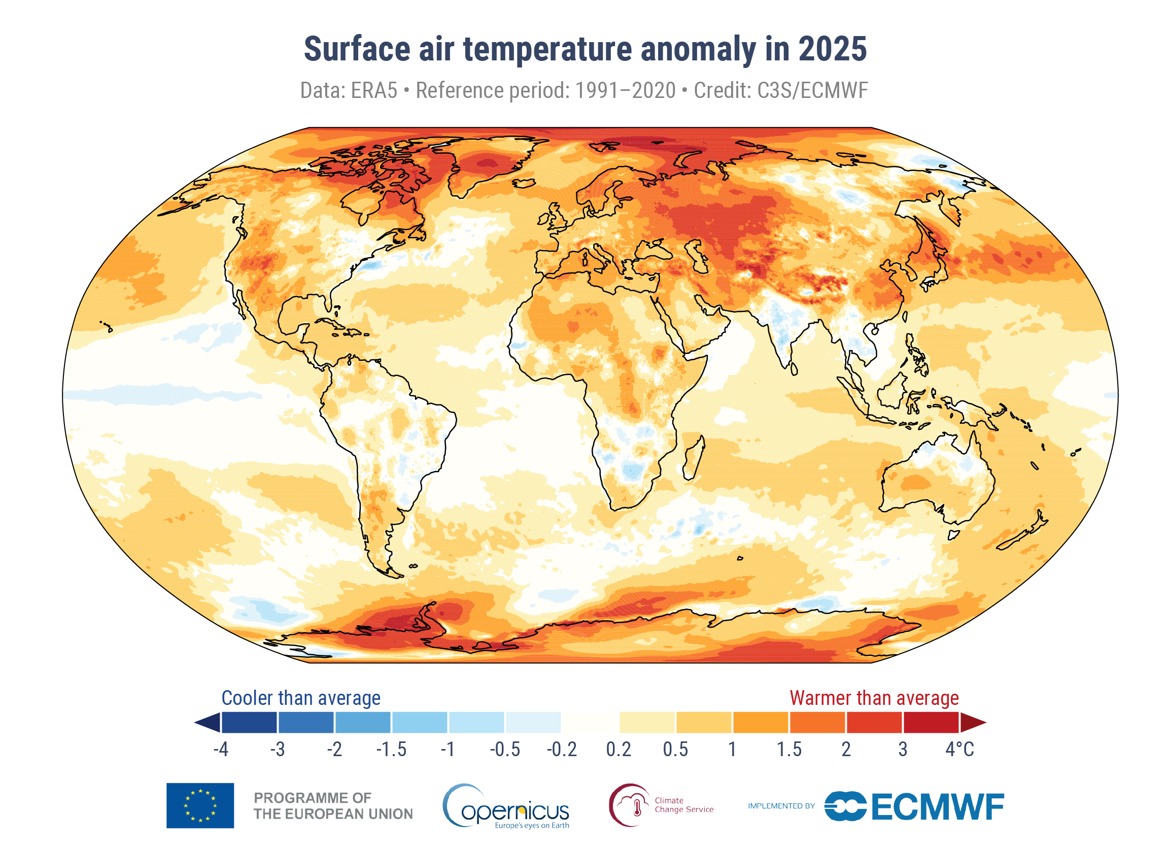
The year of 2025 was the 5th warmest since 1931 and the 3rd wettest since 2000, in mainland Portugal.
In 2025, the annual average air temperature, 16.47 °C, was +0.81 °C above the 1991–2020 normal. The last four years are among the five warmest ever recorded in Portugal (1997, 2022, 2023, 2024, and 2025).
The average maximum air temperature was the 4th highest, and the average minimum the 7th highest since 1931, with anomalies of +0.97 °C and +0.65 °C, respectively.
Regarding precipitation, 2025 was the 3rd wettest year since 2000. It had been 11 years since a year so wet had been recorded in mainland Portugal. The total annual precipitation was 1064.8 mm, with a deviation of +245.5 mm compared to the 1991–2020 normal.
Discover Our Partners