End of 2025 and beginning of 2026 marked by an exceptionally wet period in mainland Portugal
The last quarter ranks among the wettest since 1931, and this February was the wettest in 47 years of records.
In the 4-month period between 1 November 2025 and the end of February 2026, mainland Portugal recorded one of the rainiest periods of the last decades. According to the available data, this was the 6th wettest period since 1931 and the wettest in 30 years, with precipitation values above average across the entire territory.
The 2025/2026 hydrological year, which began on 1 October, also stands out as one of the wettest of the last 30 years. So far, it is the wettest since 1996, with accumulated totals reaching 1.5 to 2 times the normal value in most river basins. In several regions, the precipitation recorded is already approaching, or even matching, the average annual total expected.
This situation resulted from the predominance of westerly atmospheric circulation, responsible for the intense and persistent transport of moisture from the Atlantic (Figure 1). This pattern favoured frequent precipitation events, contributing to a significant increase in stored water volumes in the country’s main river basins.
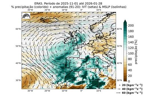
Figure 1. Anomalies (relative to 1991–2020) over the Euro-Atlantic region for the period 1 November 2025 to 28 February 2026 for the following fields: mean sea level pressure, integrated water vapour transport (IVT), and total precipitation. Source: ERA5 / Copernicus Climate Change Service (C3S).
January was the 2nd wettest of the century
The month of January 2026 stood out in particular, with a total precipitation amount about twice the monthly average. It ranked as the 2nd wettest January since 2000 and the 14th wettest since 1931.
All meteorological stations recorded above-normal precipitation. Across much of the country, rainfall ranged between 150% and 300% of the climatological average, locally reaching even higher values.
All municipalities recorded soil water values above field capacity (>100%), with municipalities in the northern interior, central region, and southern coastal areas very close to full soil saturation.
The preliminary summary of the analysis by IPMA regarding January 2026 is available in the corresponding monthly report.

Figure 2. Flooded road in Serpa, Beja. Photo credit: José Sena Goulão / Agência Lusa.
February was the wettest in the last 47 years, placing the 2025/26 hydrological year above 2000/01
Just 15 days of intense rainfall were enough for February to become the wettest in the last 47 years. The month finished as the 5th wettest since 1931, with a total accumulation of 241.7 mm (329% of normal, i.e. more than three times the 1991–2020 average reference value).
Across much of the country, totals ranged between 300% and 400% (three to four times) the 1991–2020 normal, reaching over 500% (five times) in locations such as Mora, Barreiro (Lavradio), and Alvalade do Sado.
The accumulated precipitation from 1 October 2025 (the start of the hydrological year) to 28 February 2026 reached 924.0 mm, corresponding to 1.8 times the average value, surpassing the 2000/01 hydrological year, which had previously been the reference for the last 25 years.
By the end of the month, all municipalities recorded soil water values between 60% and 100%. In the northern regions, the interior of the central region, and some municipalities in the interior of the upper Alentejo, soils were at saturation levels. In north-eastern Trás-os-Montes, soils were close to supersaturation.
But why has it been raining so much?
The role of the jet stream in the current weather pattern
The current behaviour of the jet stream is the main factor responsible for the weather pattern currently affecting the country. This powerful band of air, which circulates in the upper troposphere (~9–10 km altitude), has often been stronger and positioned further south than is typical for this time of year.
A stronger jet stream acts like a conveyor belt, promoting the rapid development and transport of low-pressure systems towards north-western and south-western Europe. When it shifts southward over the Atlantic, it tends to channel these systems directly towards Western Europe, particularly southern United Kingdom and the Iberian Peninsula, increasing both the frequency and intensity of fronts associated with heavy rainfall and strong winds.
During this winter, several polar air incursions over North America helped intensify the jet stream. As this cold, dense air moves southwards, it strengthens the temperature contrast with warmer subtropical air masses, which is one of the key factors that fuels the jet stream.
At the same time, an anticyclone developed over parts of northern Europe. This created a blocking pattern, preventing significant shifts in the position of the jet stream and reducing the likelihood of more stable and dry conditions. This blocking anticyclone also prevented frontal systems from moving across and dissipating over the British Isles and northern Europe. Instead, they remained almost stationary, producing persistent and slow-moving bands of rainfall (see simplified diagram in Figure 3).
Azores High displaced southwards favoured a “train of storms”
At the same time, the Azores High remained at lower latitudes than usual, on average near the latitude of the Canary Islands. As a result, between Morocco and the British Isles, passing through the Iberian Peninsula, there was for several weeks a corridor largely free of anticyclones.
Combined with a strong jet stream capable of generating depressions, this allowed the frequent and persistent passage of storms over Western Europe, with particular impact on the Iberian Peninsula and North Africa.
Furthermore, the more southerly position of the Azores High favoured the transport of moisture towards the Iberian Peninsula from the subtropical Atlantic and equatorial regions through atmospheric rivers (flows with very high water vapour content occurring in the middle and upper levels of the atmosphere).
These atmospheric rivers were associated with episodes of extreme precipitation across south-western Europe.
Thus, in mainland Portugal, after an early January marked by the depressions Francis, Goretti, Ingrid and Joseph, Storm Kristin stood out for its intensity. This depression underwent very rapid intensification, a phenomenon known as explosive cyclogenesis, leaving a trail of destruction in several regions.
A sting jet also developed, producing wind gusts exceeding 150 km/h, particularly in the regions of Leiria and Coimbra.
Later, in February, the depressions Leonardo, Marta, Nils and Oriana continued to contribute, directly or indirectly, to precipitation totals well above the seasonal average.
The combination of persistent rainfall and already supersaturated soils resulted in floods, inundations and landslides in several areas of the country.
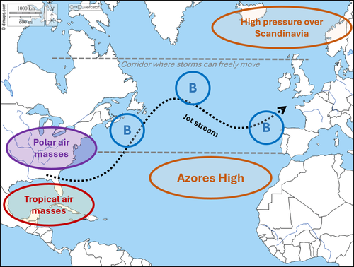
Figure 3. Simplified schematic of the meteorological systems that have been influencing atmospheric circulation over the North Atlantic. Low-pressure systems (or storms) are indicated by the letter “B”.