The hottest and driest summer on record in mainland Portugal

Heatwaves in the summer months (June, July and August) are the most noticeable and have the greatest impacts when they occur during this period, although, according to the HWDI definition, they may happen at any time of the year.
The summer of 2025 was the hottest and driest on record in mainland Portugal (since 1931).
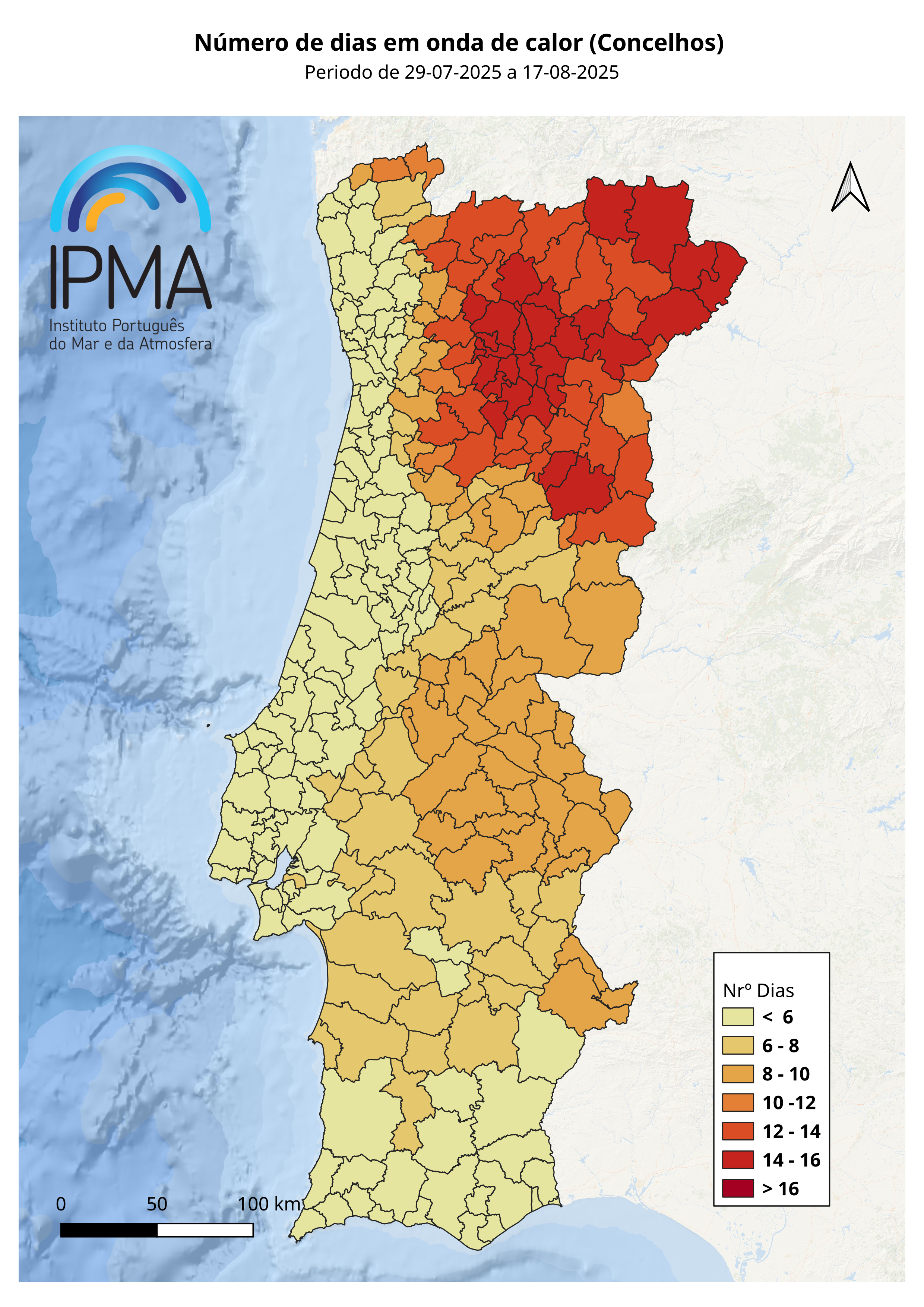
There were three heatwaves, the most significant of which occurred between 29 July and 17 August. This event was exceptional in terms of its duration and was the longest heatwave ever recorded in the northern and central inland regions.
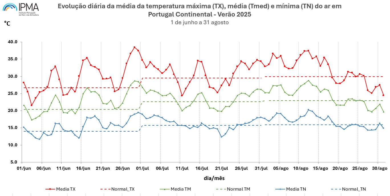
The mean maximum air temperature in summer 2025 was 30.78 °C, the highest on record, with an anomaly of +2.09 °C compared to the 1991–2020 average.
Across the three summer months, the mean, maximum and minimum air temperatures were all above their respective 1991–2020 reference values. June stood out as the third warmest since 1931, with a monthly anomaly greater than +2.0 °C. July and August were also very hot, ranking as the 9th and 5th warmest, respectively, since 1931.
Several periods with above-average air temperatures were observed, particularly for maximum temperature. The most notable were:
- 15–20 June (1st heatwave)
- 26 June – 9 July (2nd heatwave)
- 27 July – 9 August (3rd heatwave)
There were also extended periods during which both maximum and minimum air temperatures remained above the 1991–2020 monthly averages:
- 24 consecutive days (minimum temperature): 16 June – 9 July
- 25 consecutive days (minimum temperature): 25 July – 18 August
- 25 consecutive days (maximum temperature): 24 July – 17 August
Significant positive anomalies in maximum air temperature compared with the monthly means were recorded:
- +11.7 °C and +10.7 °C on 29 and 30 June
- +7.5 °C on 11 and 12 August
The hottest day of summer 2025, considering both mean maximum and minimum air temperatures, occurred on 12 August, with a national mean of 28.82 °C.
The highest maximum temperature of the summer was recorded on 29 June (38.45 °C), while the highest minimum temperature was observed on 12 August (20.25 °C).
Heatwaves in the summer months (June, July and August) are the most striking and impactful, although, according to the definition of the Heat Wave Duration Index (HWDI), they may occur at any time of the year.
2003 and 2005: two similar yet distinct heatwaves

The 2025 heatwave shows many similarities with the 2003 event in terms of average duration and magnitude, but with differences in spatial distribution.
In 2025, the northern and central inland regions recorded more heatwave days than in 2003, with several stations reporting over 14 days. By contrast, the 2003 heatwave lasted longer in the Tagus Valley and the Alentejo interior.
In 2003, two meteorological stations – Portalegre and Mora – recorded a maximum of 17 consecutive heatwave days, whereas in 2025 the highest value was 16 days in Guarda.
In terms of magnitude (defined as the sum of the deviations of daily maximum air temperature from its daily average during the reference period, across the heatwave), the 2003 event registered the highest magnitudes in the Tagus Valley and Upper Alentejo, while in 2025 the highest magnitudes occurred in the northern and north-central inland regions.
It can therefore be concluded that, for the July–August period, the 2025 heatwave was the longest ever recorded and the most intense in terms of magnitude in the northern and central inland regions – the same regions that were the most severely affected by wildfires during the summer of 2025.
It should be noted that the definition used here follows the Heat Wave Duration Index (HWDI), as established by the World Meteorological Organization (WCDMP-No.47, WMO-TD No.1071).
A heatwave is defined as a period of at least six consecutive days during which the daily maximum air temperature exceeds the daily average (reference period) by 5 °C or more.