A warmer-than-normal start of October marks the 6th heatwave in Portugal mainland
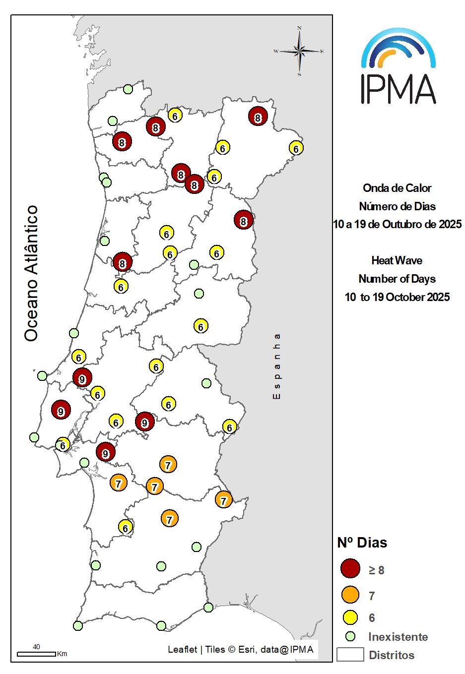
In mainland Portugal, the beginning of October was marked by a significantly prolonged warm period. This period resulted in a heatwave that lasted from October 10 to 19, recorded by 65% of the meteorological stations. The regions most affected by temperatures well above the average for October were Lisbon and the Tagus Valley, much of the North region (Trás-os-Montes and Alto Douro), as well as parts of the Alto Alentejo and Central Alentejo regions. The average magnitude of this heatwave was 49.3°C.
For context: the magnitude of a heatwave, for a given meteorological station, is calculated by summing the anomalies relative to the reference normal period (in this case, 1991–2020) for all days on which a heatwave was observed. For comparison, the heatwave from July 29 to August 17, 2025, recorded an average magnitude of 78.8°C, while the August 2003 heatwave had an average magnitude of 78.6°C.
The meteorological stations that recorded the highest number of heatwave days were Mora, Pegões, Torres Vedras (Dois Portos), and Rio Maior, each observing 9 consecutive days. The geographical distribution of the number of heatwave days per station can be seen in Figure 1, on the right.
Heatwaves registered in Portugal mainland so far this year

Throughout 2025, mainland Portugal experienced at least six heatwaves, which are listed and summarized below:
May 24 to June 1, 2025
Following a wet late winter and spring, the first heatwave of 2025 occurred between May 28 and 31, with over 70% of meteorological stations recording maximum temperatures ≥ 30.0 °C, and on May 29 and 30 more than 10% of stations registering maximum temperatures ≥ 38.0 °C. The highest maximum temperature, 39.9 °C, was recorded on May 29 at the Coruche and Alvega stations.
A heatwave was observed at 14 meteorological stations between May 24 and July 1, affecting parts of the central interior, the Tagus Valley, and the Alentejo region; Mértola stood out with an 8-day duration.
June 15 to 20, 2025
This was the first heatwave of the summer and the second of the year, lasting six days (June 15–20) and affecting the northern and central inland regions as well as Upper Alentejo. During this period, anomalies above +5.0 °C (June 17–19) were recorded in mean air temperature, while maximum temperature anomalies reached +7.9 °C (June 16) and +8.7 °C (June 17).
June 29 to July 9, 2025
The second summer heatwave lasted 14 days (June 29–July 9), affecting much of northern Portugal, the central interior, Alentejo, and the eastern Algarve. On June 29 (the onset of the heatwave), 30 IPMA meteorological stations equaled or exceeded their previous highest maximum air temperatures. A new absolute June temperature record for mainland Portugal was set in Mora, with 46.6 °C (previous record: 44.9 °C in Alcácer do Sal on June 17, 2017). On June 29 and 30, six new record-high minimum air temperatures were also observed, with Viseu standing out for exceeding the previous record by +1.7 °C.
July 29 to August 17, 2025
The period from July 29 to August 17 was extremely hot, with both maximum and minimum temperatures remaining very high, particularly in inland regions where maximum temperatures exceeded 40 °C. The heatwave that occurred during this period lasted between 6 and 17 days and was exceptional in duration. It was longest across most of northern and parts of central Portugal, and shorter in Upper Alentejo. The municipalities with the greatest number of heatwave days were Guarda (16 days), and Bragança, Miranda do Douro, Carrazeda de Ansiães, Vila Real, Pinhão, and Viseu (15 days each). The July–August 2025 heatwave was the longest ever recorded for the northern and central inland regions (the areas most affected by wildfires). During this extremely hot period, two IPMA stations (Viseu and Guarda) surpassed their previous record-high minimum air temperatures, and one (Lamas de Mouro) equaled the previous record.
September 14 to 20, 2025
A heatwave occurred from September 14 to 20, affecting some areas of the central interior. Between September 16 and 18, 25–40% of stations recorded maximum air temperatures ≥ 35 °C (very hot days). On September 17, the average maximum temperature across the country reached its highest value of the event, 32.44 °C; on that day, two meteorological stations recorded maximum air temperatures ≥ 40 °C (extremely hot days): 40.2 °C (the highest temperature) at the Portel station and 40.1 °C at the Reguengos station.
October 10 to 19, 2025
The sixth heatwave of the year occurred between October 10 and 19, 2025.