August 2025 was the 3rd warmest globally and the 5th warmest in mainland Portugal since 1931
Global
August 2025 was +0.49 °C warmer than the 1991–2020 average, with a global mean surface air temperature of 16.60 °C (see Figure 1), making it the 3rd warmest August on record. It was the 5th month in the past 26 months when the global mean air temperature anomaly was below +1.5 °C above pre-industrial levels, reaching +1.29°C.
Europe
The mean air temperature in Europe in August was 19.46 °C, which is +0.30 °C above the 1991–2020 average.
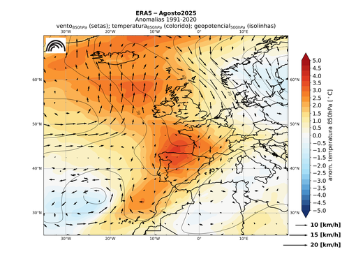
In August 2025, Western Europe recorded predominantly above-average air temperatures. The Iberian Peninsula and southwest France registered the most significant anomalies, largely due to a prolonged heatwave during the month. By contrast, much of Northern Europe – including Fennoscandia, the Baltic States and Poland – experienced below-average temperatures compared to the 1991–2020 climatology.
Regarding precipitation, much of Western, Central and Southern Europe had below-average values. Southern Sweden, north-western Russia and parts of Finland were also drier than normal. These drought conditions, combined with the heatwaves in southwestern Europe, also contributed to the spread and intensification of wildfires in the Iberian Peninsula and Greece.
On the other hand, regions of northeastern Spain, southern France, Switzerland and Germany, much of Italy, the northern Adriatic coast, much of Scandinavia, and a large area extending from the Baltic States eastwards into Russia recorded above-average precipitation.
Mainland Portugal
August 2025 was classified as very hot in terms of mean air temperature and very dry in terms of precipitation.
Air temperature:
- It was the 5th warmest August since 1931, with a mean air temperature of 24.40 °C, +1.49 °C above the 1991–2020 average.
- The mean maximum and minimum air temperatures were also above average (+1.93 °C and +1.04 °C, respectively).
- From the start of the month until 17 August, daily air temperature values remained consistently above the monthly mean, with the most significant deviations in mean and maximum temperatures. In the remainder of the month, values were close to or below average, particularly after 27 August.
- The heatwave from 29 July to 17 August was the longest on record in the northern and central inland regions for the July–August period:
- Longest duration: Guarda, 16 days;
- 15 days in Bragança, Miranda do Douro, Carrazeda de Ansiães, Vila Real, Pinhão and Viseu.
- It was also the most intense heatwave in the northern and central inland regions for the July–August period.
Precipitation:
- It was the 7th driest August since 2000, with total rainfall of only 3.0 mm, around 20% of the 1991–2020 average.
Meteorological drought:
- There was a significant increase in the area under drought, extending across almost the entire mainland territory, with a worsening of intensity in the northwest, central-southern inland regions and Baixo Alentejo.

Figure 1. Anomalies of temperature (850hPa), wind (850hPa) and geopotential (500hPa), in August 2025. Source: C3S/ERA5