February 2026, the wettest in 47 years
Globally
Globally, February 2026 was 0.53 °C warmer than the 1991–2020 average, with a mean near-surface air temperature of 13.26 °C, making it the 5th warmest February on record.
It recorded a temperature +1.49 °C above the estimated average for the 1850–1900 period (pre-industrial level).
Europe
The average air temperature in Europe in February was −0.07 °C, 0.10 °C below the 1991–2020 average.
In February 2026, a strong contrast in mean temperatures was observed across Europe. Western, eastern and south-eastern Europe, as well as Turkey, recorded above-average temperatures, with the largest anomalies observed in Turkey. In contrast, widespread cold conditions continued in Fennoscandia, the Baltic States and north-western Russia, marking the second consecutive month in which these regions recorded below-average temperatures.
Much of western and south-eastern Europe, including Turkey and part of the Caucasus region, experienced wetter and warmer than average conditions, while the rest of the continent was generally drier and colder than average.
The passage of several named storms, such as Leonardo, Marta, Nils, Oriana and Pedro, brought intense precipitation to western and southern Europe. France recorded its wettest February on record. Precipitation frequently occurred over soils already saturated after a wet January, triggering floods and landslides in Spain and Portugal, and also affecting France, Italy and North Africa, with widespread damage.
In North Africa, although the heavy rainfall caused significant disruption, it also brought some relief to a severe drought that had lasted seven years in Morocco.
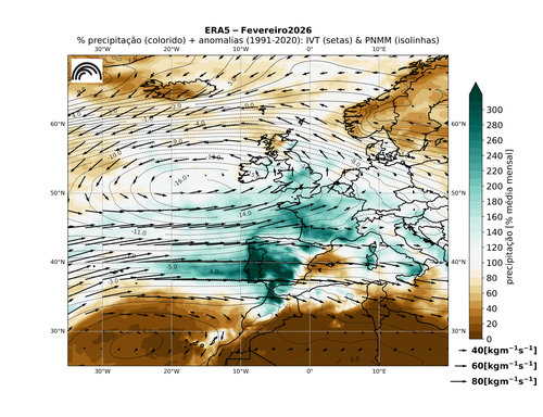
Figure 1. Anomalies (1991-2020 reference period) for mean sea level pressure and humidity transport, as well as rainfall percentages for February 2026. Source: C3S/ERA5
Mainland Portugal
The month of February 2026 was classified as very warm in terms of mean air temperature and extremely wet in terms of precipitation.
Air Temperature
- It was the 7th warmest February on record, with a mean air temperature of 11.66 °C, +1.79 °C above the 1991–2020 normal.
- The mean maximum temperature, 15.62 °C, was +0.91 °C above the average, while the mean minimum temperature, 7.70 °C, was +2.67 °C above the normal value.
Precipitation
- It was the 5th wettest February since records began, and the wettest February in the last 47 years.
- Across much of the country, precipitation totals reached three to four times the 1991–2020 normal, and even more than five times the normal value in the localities of Mora, Barreiro (Lavradio) and Alvalade do Sado.
Highlights in mainland Portugal
During the first half of February, successive low-pressure systems continued to cross mainland Portugal, associated with the transport of large amounts of moisture (atmospheric rivers) and persistent precipitation: Storms Leonardo and Marta (4–7) and frontal systems associated with Storms Nils and Oriana (10–13).
The hydrological year was the wettest of the last 30 years and the 6th wettest since 1931. The accumulated precipitation for the period from 1 October 2025 to 28 February 2026 (924 mm) corresponds to 1.8 times the average value of the hydrological year.
All municipalities recorded soil water values between 60% and 100%. In the northern region, the central interior and some municipalities in the interior of Alto Alentejo, soils were already at saturation levels. In north-eastern Trás-os-Montes, the soil was close to supersaturation.
Have acess to the climate bulletin for February 2026 (portuguese version only): Climate bulletin for February 2026
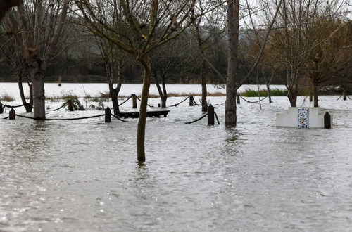
Figure 2. Flooding in Alcácer do Sal region. Credit: Paulo Novais / Lusa